trail walk
Return to Pirate's Adventure Page
Mr. Pirate bought a book, Walking San Francisco on the Barbary Coast Trail, by Daniel Bacon (ISBN 0-9646804-1-6). It's a wonderful book that breaks downtown San Francico into small, walkable areas that have been designated as part of the Barbary Coast Trail. It contains a wealth of very entertaining information about the historical background of what San Francisco was like from the time of the Gold Rush (1849) through the aftermath of the 1906 Earthquake and Fire. The original Barbary Coast was along the coastline of the Mediterrean Sea of north Africa .. a wild area populated by pirates and brigands in the times of sailing ships. (Heck, it may still be that way for all I know). Allegedly, during the 1860's, a sailor imbibing in one of the many saloons northeast of current day Portsmouth Square, was heard to compare that general area of San Francisco to the original Barbary Coast and it stuck.
San Francisco's Barbary Coast was well known for its licentious ways, multitude of saloons, loose women, and gambling houses. During its high point in the 1860's and 1870's, it was bordered by (current day) Embarcadero, (current day) Grant Street, north Broadway and Commercial Street ... a 40 square block area! If you look at the picture at the top of the page, you'll see a VERY SMALL area shaded in red. That's the curent day Barbary Coast. The original boundaries are in dotted red. Many, many unlucky men (sailors and non-sailors) were routinely shanghied from shady drinking houses directly to nearby ships bound for the Far East. (In fact, author Danile Bacon claims that the term "shanghied" originated in the Barbary Coast to mean kidnapped & sent to sea.)
And WHY would you think that such a large area was thought of as *coastline* and how could sailors get shanghied to nearby ships??? Well, the shoreline of the bay was substantially inland of where it is now. Most of the financial district is actually fill. The original waterline used to come up to *MONTGOMERY STREET*!!!
Today, the Barbary Coast is merely a historic part of Jackson Square (interestingly, there IS no "Jackson Square" as in a park, but is simply a name for the area).
At the end of this page, I'll put links to historic photos showing just how unbelieveably rustic San Francicco (originally named Yerba Buena) was. While Mr. Pirate and I were researching maps, we discovered that Columbus street, one of the current day main diagonal thoroughfares, didn't even EXIST in the 1800's. It's very, very weird looking at those old maps.
We started out at the Montgomery BART station (off the bottom of the map). We walked north on Montgomery, towards Columbus Avenue. This is the heart of the financial district and the canyons created by the ginormous skycrapers are incredibly windy and shaded from the sun.
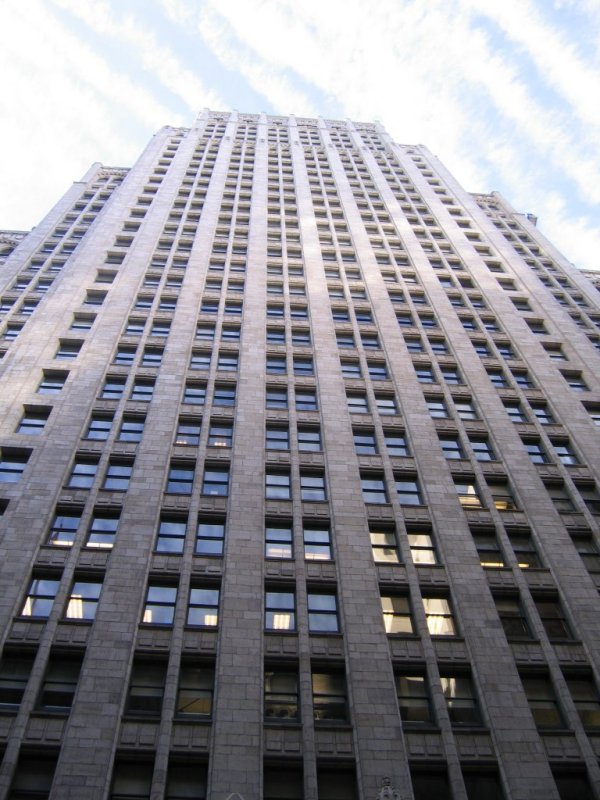 As we walked towards our first point of interest, I happened to look up, up, up at one of the buildings.
The perspective from street level to the top of this bazillion story building was dizzying.
The illusion of the world rushing by was augmented by the feathery clouds slipping past the top of the building at breakneck speed.
I'm sure that if I continued walking whilst looking up, I really would have broken my neck.
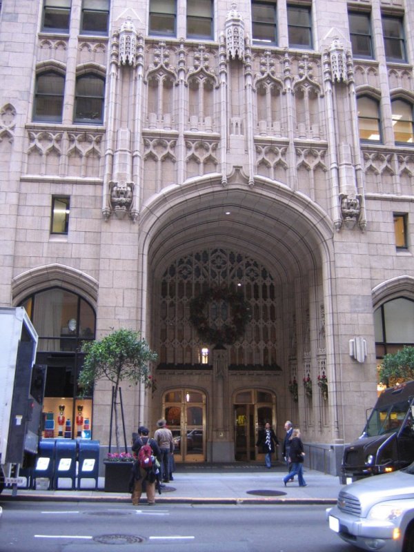 Then I noticed the entrance to the building was incredible! What a great inspiration for a quilting design!
I do wish I had noted which building it was .... I haven't a clue except that it's on Montgomery closer to Market Street than farther away.
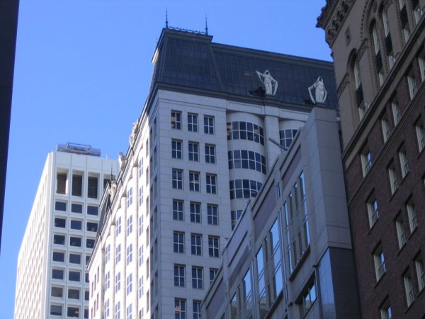 Then, as we continued to walk along, I commented on how people are so busy keeping track of where they are walking, they rarely look UP.
The architecture of many of the old buildings farther up the facade is simply amazing, if only people knew it was there to be admired.
One case point is the building on a cross-street (again, I don't remember which one) that has STATUARY at the roofline! Who KNEW that stuff was there???
I think it would be a great view if your office was directly opposite them.
One other very disturbing realization came to us during the course of this walk ... there is a LOT of brick facades! Both of us being natives to San Francisco, it has been drummed into us that because of earthquakes, brick facades are not used; they are too dangerous. During earthquakes, the bricks will separate from the building and become fatal projectiles to the unfortunate pedestrians below. Once we started noticing all the frickin' BRICKS around us .. not to mention GLASS WALLS on all those high rises ... we realized that the sheer depth of debris during an earthquake is going to be tremendous.
Moral of the story: don't be in downtown San Francisco during the next earthquake. (Personally, I want to be in a hot air balloon.)
But, enough of doom and gloom .... on with the walking tour!
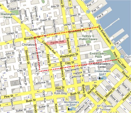
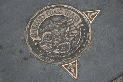 Following the excellent directions in Walking San Francisco on the Barbary Coast Trail, the map below shows the walking tour we took in red dotted lines, starting at the big green star at the bottom and ending at the red star. The Barbary Coast Trail has markers imbedded in the sidewalk at various place to let you know you're on the right heading.
The green numbers are points of interest from the book and are hot links. If you click on them, a new window will open up with a photo of what's there now and why it was included in the book ... so scroll down when the new window opens.
The shaded green line is what is now considered the Barbary Coast. You'll notice the wavy blue line and shaded blue areas? That's the more-or-less accurate rendition of where the original waterline was during the time of the Gold Rush ... mid 1850's.
That's why the Barbary Coast was not a misnomer ... the WATER was there. Duh.
Please note that the current day Transamerica Pyramid would have been in the water. :-)
The Barbary Coast walking tour ends at Columbus, Kearny and Pacific (the red star).

So, now you've walked through the historic Barbary Coast. Mr. Pirate and I took our tour on the day after Christmas, so there was virtually NO ONE in the City. Gosh, it was wonderful. If only all those crazy people would leave, San Francisco would be a lovely place. :-)
For those of you who are interested in seeing what the REALLY EARLY pre-Gold Rush days of San Francisco looked like, I have some incredible links for you.
The verbage on the map says "Compiled from a map of W.M. Eddy, City Surveyor, January 15, 1851 (from the collection of C.B. Turrill), and maps printed in Parker's City Directory, 1852 and in H.H. Bancroft's History of California, vol 8, page 169. The shaded portion shows the area in process of reclamation from the Bay. Battery Street was built up by 1850. Front Street, north of Market, and Davis, were occupied during 1852 and as the shore line advanced, the wharves were constantly extended into deeper water."
Please note that the City Surveyor was W.M. Eddy. Anyone familiar with Eddy Street? Well, that's the guy it's named for!
From the end of the Babary Coast walk, we continued onto the walking tour of North Beach, since it's just "up" Columbus Avenue. Sadly, I never did get around to writing the verbage for that part of our Adventure. Over the passage of time, the details have been lost so there is no "Continuing Adventure to North Beach".
|
Return to Pirate's Adventure Page
[an error occurred while processing this directive]